- 7.9 24km SE of Little Sitkin Island, Alaska 2014-06-23 22:53:09 UTC+02:00 107.5 km
- 6.9 96km SSE of Raoul Island, New Zealand 2014-06-23 21:19:16 UTC+02:00 20.0 km
- 6.3 87km SSE of Raoul Island, New Zealand 2014-06-23 21:21:48 UTC+02:00 20.0 km
- 6.2 85km SSE of Raoul Island, New Zealand 2014-06-23 22:06:19 UTC+02:00 20.0 km
- 6.0 6km WNW of Little Sitkin Island, Alaska 2014-06-23 23:11:41 UTC+02:00 106.8 km
- 5.9 11km WNW of Little Sitkin Island, Alaska 2014-06-23 23:30:47 UTC+02:00 109.1 km
- 5.9 Kermadec Islands, New Zealand 2014-06-24 00:20:04 UTC+02:00 10.0 km
- 5.9 3km ENE of Little Sitkin Island, Alaska 2014-06-24 00:29:51 UTC+02:00 103.1 km
- 5.5 102km S of Raoul Island, New Zealand 2014-06-24 00:15:50 UTC+02:00 10.0 km
- 5.4 46km ESE of Kainantu, Papua New Guinea 2014-06-23 15:47:43 UTC+02:00 121.3 km
- 5.4 90km SSE of Raoul Island, New Zealand 2014-06-23 22:28:02 UTC+02:00 25.6 km
- 5.4 161km SSE of Raoul Island, New Zealand 2014-06-23 23:08:53 UTC+02:00 10.0 km
- 5.3 110km SSE of Raoul Island, New Zealand 2014-06-23 22:23:32 UTC+02:00 9.2 km
- 5.2 85km ENE of Hihifo, Tonga 2014-06-23 07:33:30 UTC+02:00 10.0 km
- 5.1 33km ENE of Norsup, Vanuatu 2014-06-23 11:10:14 UTC+02:00 149.5 km
- 5.1 157km WSW of Abepura, Indonesia 2014-06-23 17:13:04 UTC+02:00 53.7 km
- 5.1 168km SE of Raoul Island, New Zealand 2014-06-23 22:59:07 UTC+02:00 10.0 km
- 5.1 11km N of Little Sitkin Island, Alaska 2014-06-24 00:03:28 UTC+02:00 117.3 km
- 5.1 Kermadec Islands, New Zealand 2014-06-24 00:33:47 UTC+02:00 10.0 km
- 5.1 Kermadec Islands, New Zealand 2014-06-24 01:53:26 UTC+02:00 10.0 km
- 4.9 77km N of Lae, Papua New Guinea 2014-06-23 09:36:33 UTC+02:00 56.9 km
- 4.9 Rat Islands, Aleutian Islands, Alaska 2014-06-24 00:47:53 UTC+02:00 117.5 km
- 4.9 108km SSE of Raoul Island, New Zealand 2014-06-24 00:48:58 UTC+02:00 10.0 km
- 4.8 South of the Kermadec Islands 2014-06-23 11:35:52 UTC+02:00 46.5 km
- 4.8 Northern Mid-Atlantic Ridge 2014-06-23 16:30:39 UTC+02:00 10.0 km
- 4.8 101km S of Taron, Papua New Guinea 2014-06-23 17:38:38 UTC+02:00 43.6 km
- 4.8 98km S of Taron, Papua New Guinea 2014-06-23 18:25:22 UTC+02:00 38.1 km
- 4.8 7km WSW of Little Sitkin Island, Alaska 2014-06-23 23:42:57 UTC+02:00 116.9 km
- 4.8 7km N of Little Sitkin Island, Alaska 2014-06-24 01:39:32 UTC+02:00 100.0 km
- 4.7 Northern Mid-Atlantic Ridge 2014-06-23 17:21:18 UTC+02:00 10.0 km
- 4.7 5km WSW of Namangan Shahri, Uzbekistan 2014-06-23 17:30:09 UTC+02:00 29.4 km
- 4.7 Rat Islands, Aleutian Islands, Alaska 2014-06-24 00:18:37 UTC+02:00 118.0 km
- 4.6 47km NNE of Muminobod, Tajikistan 2014-06-23 02:27:54 UTC+02:00 16.9 km
- 4.6 112km SSE of Raoul Island, New Zealand 2014-06-23 23:55:38 UTC+02:00 6.6 km
- 4.5 20km SE of Puerto Armuelles, Panama 2014-06-23 09:43:26 UTC+02:00 47.4 km
- 4.5 16km SW of Little Sitkin Island, Alaska 2014-06-24 01:33:52 UTC+02:00 94.1 km
- 4.4 Panama-Costa Rica border region 2014-06-23 21:13:17 UTC+02:00 23.9 km
- 4.4 20km WSW of Little Sitkin Island, Alaska 2014-06-24 00:16:04 UTC+02:00 118.0 km
- 4.2 Northern Mid-Atlantic Ridge 2014-06-23 15:28:52 UTC+02:00 8.2 km
- 4.0 Rat Islands, Aleutian Islands, Alaska 2014-06-24 01:32:11 UTC+02:00 117.0 km
(Quelle)
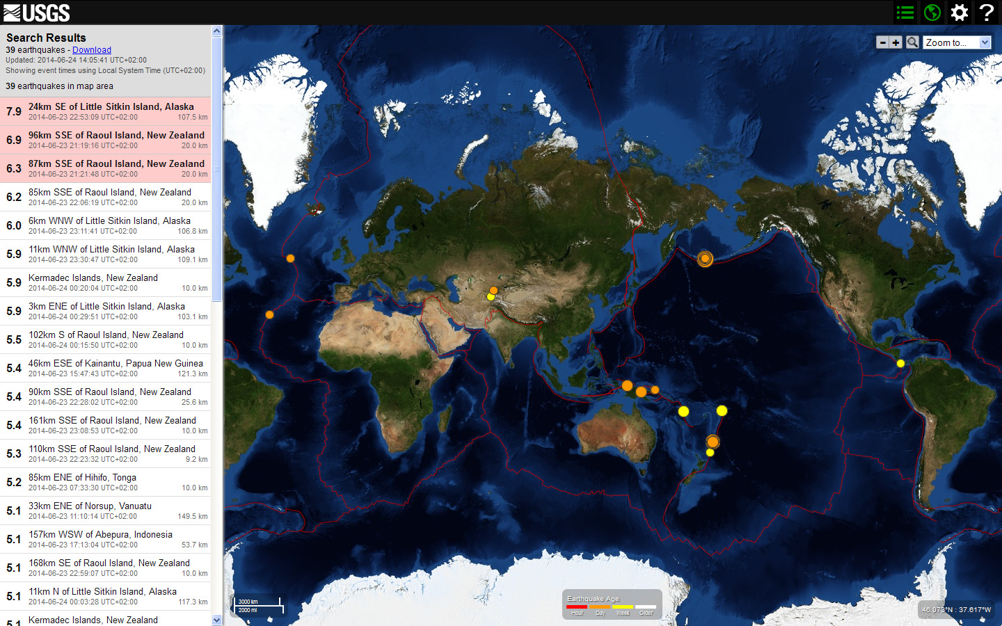
Das stärkste Beben mit 7.9, das von 8.0 heruntergestuft wurde, ereignete sich bei Little Sitkin Island, einer Vulkaninsel der Aleuten, die zu den Rat Islands gehört. Hier gab es insgesamt 12 Erdbeben:
12 Erdbeben Alaska - Aleuten

- 7.9 24km SE of Little Sitkin Island, Alaska 2014-06-23 22:53:09 UTC+02:00 107.5 km
- 6.0 6km WNW of Little Sitkin Island, Alaska 2014-06-23 23:11:41 UTC+02:00 106.8 km
- 5.9 11km WNW of Little Sitkin Island, Alaska 2014-06-23 23:30:47 UTC+02:00 109.1 km
- 5.9 3km ENE of Little Sitkin Island, Alaska 2014-06-24 00:29:51 UTC+02:00 103.1 km
- 5.1 11km N of Little Sitkin Island, Alaska 2014-06-24 00:03:28 UTC+02:00 117.3 km
- 4.9 Rat Islands, Aleutian Islands, Alaska 2014-06-24 00:47:53 UTC+02:00 117.5 km
- 4.8 7km WSW of Little Sitkin Island, Alaska 2014-06-23 23:42:57 UTC+02:00 116.9 km
- 4.8 7km N of Little Sitkin Island, Alaska 2014-06-24 01:39:32 UTC+02:00 100.0 km
- 4.7 Rat Islands, Aleutian Islands, Alaska 2014-06-24 00:18:37 UTC+02:00 118.0 km
- 4.5 16km SW of Little Sitkin Island, Alaska 2014-06-24 01:33:52 UTC+02:00 94.1 km
- 4.4 20km WSW of Little Sitkin Island, Alaska 2014-06-24 00:16:04 UTC+02:00 118.0 km
- 4.0 Rat Islands, Aleutian Islands, Alaska 2014-06-24 01:32:11 UTC+02:00 117.0 km
Sehr viele starke Beben ereigneten sich auch auf den Kermadecinseln von Neuseeland, die stärksten mit 6.9, 6.3 und 6.2. Hier gab es insgesamt 14 Erdbeben:
14 Erdbeben Kermadecinseln:

- 6.9 96km SSE of Raoul Island, New Zealand 2014-06-23 21:19:16 UTC+02:00 20.0 km
- 6.3 87km SSE of Raoul Island, New Zealand 2014-06-23 21:21:48 UTC+02:00 20.0 km
- 6.2 85km SSE of Raoul Island, New Zealand 2014-06-23 22:06:19 UTC+02:00 20.0 km
- 5.9 Kermadec Islands, New Zealand 2014-06-24 00:20:04 UTC+02:00 10.0 km
- 5.5 102km S of Raoul Island, New Zealand 2014-06-24 00:15:50 UTC+02:00 10.0 km
- 5.4 90km SSE of Raoul Island, New Zealand 2014-06-23 22:28:02 UTC+02:00 25.6 km
- 5.4 161km SSE of Raoul Island, New Zealand 2014-06-23 23:08:53 UTC+02:00 10.0 km
- 5.3 110km SSE of Raoul Island, New Zealand 2014-06-23 22:23:32 UTC+02:00 9.2 km
- 5.1 168km SE of Raoul Island, New Zealand 2014-06-23 22:59:07 UTC+02:00 10.0 km
- 5.1 Kermadec Islands, New Zealand 2014-06-24 00:33:47 UTC+02:00 10.0 km
- 5.1 Kermadec Islands, New Zealand 2014-06-24 01:53:26 UTC+02:00 10.0 km
- 4.9 108km SSE of Raoul Island, New Zealand 2014-06-24 00:48:58 UTC+02:00 10.0 km
- 4.8 South of the Kermadec Islands 2014-06-23 11:35:52 UTC+02:00 46.5 km
- 4.6 112km SSE of Raoul Island, New Zealand 2014-06-23 23:55:38 UTC+02:00 6.6 km
Juskis Erdbeben News veröffentlichte hierzu den Artikel "Schwere Erdbeben (M 6.5 bis 6.9) auf den Kermadec-Inseln, Neuseeland". Wegen der Subduktion der Pazifischen Platte unter die Indo-Australische Platte komme es in dieser Region regelmäßig zu schweren Erdbeben und vulkanischen Tätigkeiten. Schäden gäbe es aber aufgrund der dünnen Besiedlung meist nicht.
14 Erdbeben im Rest der Welt:
Ansonsten viermal Papua-Neuguinea, Tonga, Vanuatu, Indonesien, dreimal am nördlichen Mittelatlantischen Rücken, Usbekistan, Tadschikistan und Panama und im Grenzgebiet Panama-Costa Rica.
EMSC meldete insgesamt 44 Beben > 4 weltweit:

| 2014-06-23 20:53:09.6 | 51.85 | N | 178.76 | E | 106 | 7.9 | RAT ISLANDS, ALEUTIAN ISLANDS | |||||
| 2014-06-23 21:11:40.9 | 52.01 | N | 178.48 | E | 100 | 6.0 | RAT ISLANDS, ALEUTIAN ISLANDS | |||||
| 2014-06-23 22:20:13.1 | 29.96 | S | 177.20 | W | 60 | 5.9 | KERMADEC ISLANDS, NEW ZEALAND | |||||
| 2014-06-23 21:30:46.1 | 51.94 | N | 178.42 | E | 100 | 5.8 | RAT ISLANDS, ALEUTIAN ISLANDS | |||||
| 2014-06-23 22:29:52.0 | 51.98 | N | 178.61 | E | 105 | 5.8 | RAT ISLANDS, ALEUTIAN ISLANDS | |||||
| 2014-06-23 21:08:53.0 | 30.48 | S | 176.93 | W | 10 | 5.6 | KERMADEC ISLANDS REGION | |||||
| 2014-06-23 22:15:49.4 | 30.26 | S | 177.55 | W | 2 | 5.5 | KERMADEC ISLANDS, NEW ZEALAND | |||||
| 2014-06-23 20:59:09.1 | 30.57 | S | 176.65 | W | 2 | 5.4 | KERMADEC ISLANDS REGION | |||||
| 2014-06-23 22:40:51.6 | 25.56 | N | 151.66 | E | 10 | 5.4 | EAST OF THE VOLCANO ISLANDS | |||||
| 2014-06-23 22:33:47.4 | 30.36 | S | 177.60 | W | 10 | 5.1 | KERMADEC ISLANDS, NEW ZEALAND | |||||
| 2014-06-23 23:53:28.0 | 30.03 | S | 177.22 | W | 10 | 5.1 | KERMADEC ISLANDS, NEW ZEALAND | |||||
| 2014-06-23 22:03:28.4 | 52.04 | N | 178.42 | E | 123 | 5.0 | RAT ISLANDS, ALEUTIAN ISLANDS | |||||
| 2014-06-23 22:48:58.0 | 30.18 | S | 177.47 | W | 10 | 4.9 | KERMADEC ISLANDS, NEW ZEALAND | |||||
| 2014-06-23 21:42:57.1 | 51.92 | N | 178.41 | E | 117 | 4.8 | RAT ISLANDS, ALEUTIAN ISLANDS | |||||
| 2014-06-23 22:47:53.6 | 52.08 | N | 178.44 | E | 122 | 4.8 | RAT ISLANDS, ALEUTIAN ISLANDS | |||||
| 2014-06-23 22:18:37.3 | 52.06 | N | 178.33 | E | 118 | 4.7 | RAT ISLANDS, ALEUTIAN ISLANDS | |||||
| 2014-06-23 21:55:38.5 | 30.22 | S | 177.49 | W | 7 | 4.6 | KERMADEC ISLANDS, NEW ZEALAND | |||||
| 2014-06-23 23:33:52.3 | 51.88 | N | 178.36 | E | 100 | 4.6 | RAT ISLANDS, ALEUTIAN ISLANDS | |||||
| 2014-06-23 23:39:30.5 | 51.87 | N | 178.51 | E | 93 | 4.6 | RAT ISLANDS, ALEUTIAN ISLANDS | |||||
| 2014-06-23 22:16:04.0 | 51.88 | N | 178.24 | E | 118 | 4.4 | RAT ISLANDS, ALEUTIAN ISLANDS | |||||
| 2014-06-23 20:53:09.6 | 51.85 | N | 178.76 | E | 106 | 7.9 | RAT ISLANDS, ALEUTIAN ISLANDS | |||||
| 2014-06-23 19:19:18.1 | 30.10 | S | 177.62 | W | 26 | 6.8 | KERMADEC ISLANDS, NEW ZEALAND | |||||
| 2014-06-23 20:06:20.1 | 30.03 | S | 177.48 | W | 20 | 6.5 | KERMADEC ISLANDS, NEW ZEALAND | |||||
| 2014-06-23 19:21:50.4 | 30.00 | S | 177.33 | W | 30 | 6.3 | KERMADEC ISLANDS, NEW ZEALAND | |||||
| 2014-06-23 05:33:30.9 | 15.58 | S | 173.11 | W | 10 | 5.5 | TONGA | |||||
| 2014-06-23 20:23:31.8 | 30.21 | S | 177.22 | W | 2 | 5.4 | KERMADEC ISLANDS, NEW ZEALAND | |||||
| 2014-06-23 20:28:02.2 | 30.05 | S | 177.64 | W | 26 | 5.4 | KERMADEC ISLANDS, NEW ZEALAND | |||||
| 2014-06-23 13:47:44.4 | 6.45 | S | 146.28 | E | 132 | 5.3 | EASTERN NEW GUINEA REG., P.N.G. | |||||
| 2014-06-23 07:36:33.8 | 6.01 | S | 147.12 | E | 60 | 5.1 | EASTERN NEW GUINEA REG., P.N.G. | |||||
| 2014-06-23 09:10:15.1 | 15.97 | S | 167.70 | E | 149 | 5.1 | VANUATU | |||||
| 2014-06-23 15:38:37.2 | 5.35 | S | 153.05 | E | 30 | 5.0 | NEW IRELAND REGION, P.N.G. | |||||
| 2014-06-23 09:35:52.1 | 34.47 | S | 178.95 | W | 44 | 4.9 | SOUTH OF KERMADEC ISLANDS | |||||
| 2014-06-23 15:13:03.8 | 3.05 | S | 139.38 | E | 46 | 4.9 | PAPUA, INDONESIA | |||||
| 2014-06-23 16:25:20.4 | 5.35 | S | 153.19 | E | 20 | 4.9 | NEW IRELAND REGION, P.N.G. | |||||
| 2014-06-23 14:30:40.4 | 30.97 | N | 41.51 | W | 10 | 4.7 | NORTHERN MID-ATLANTIC RIDGE | |||||
| 2014-06-23 15:21:18.7 | 31.04 | N | 41.45 | W | 10 | 4.7 | NORTHERN MID-ATLANTIC RIDGE | |||||
| 2014-06-23 14:30:12.1 | 29.42 | N | 46.26 | W | 33 | 4.6 | NORTHERN MID-ATLANTIC RIDGE | |||||
| 2014-06-23 19:13:18.0 | 8.72 | N | 82.69 | W | 21 | 4.6 | PANAMA-COSTA RICA BORDER REGION | |||||
| 2014-06-23 07:43:27.6 | 8.26 | N | 82.72 | W | 55 | 4.5 | PANAMA-COSTA RICA BORDER REGION | |||||
| 2014-06-23 15:30:08.8 | 41.05 | N | 71.61 | E | 30 | 4.5 | EASTERN UZBEKISTAN | |||||
| 2014-06-23 13:28:52.1 | 52.02 | N | 30.80 | W | 8 | 4.2 | NORTHERN MID-ATLANTIC RIDGE | |||||
| 2014-06-23 05:33:30.9 | 15.58 | S | 173.11 | W | 10 | 5.5 | TONGA | |||||
| 2014-06-23 00:27:53.0 | 38.40 | N | 70.39 | E | 10 | 4.6 | TAJIKISTAN | |||||
| 2014-06-23 03:42:43.0 | 44.28 | N | 24.87 | W | 2 | 4.5 | NORTHERN MID-ATLANTIC RIDGE | |||||
| 2014-06-23 04:21:20.0 | 28.66 | N | 58.04 | E | 14 | 4.1 | SOUTHEASTERN IRAN | |||||
| 2014-06-23 05:31:13.4 | 51.00 | N | 89.99 | E | 10 | 4.1 | SOUTHWESTERN SIBERIA, RUSSIA | |||||
| (Quelle) | ||||||||||||
Keine Kommentare:
Kommentar veröffentlichen