
842 > Magnitude 4:
147 > Magnitude 5:
13 > Magnitude 6:
1 > Magnitude 7
1 Beben Magnitude 7++:
Das stärkste Beben mit 7.9 ereignete sich am 23. Juni 2014 auf Alaska. Es wurde zunächst mit 8.0 angegeben und dann auf 7.9 heruntergestuft:
- 7.9 24km SE of Little Sitkin Island, Alaska 2014-06-23 22:53:09 UTC+02:00 107.5 km
12 Beben Magnitude 6++ (Vormonat: 18)
- 6.9 96km SSE of Raoul Island, New Zealand 2014-06-23 21:19:16 UTC+02:00 20.0 km
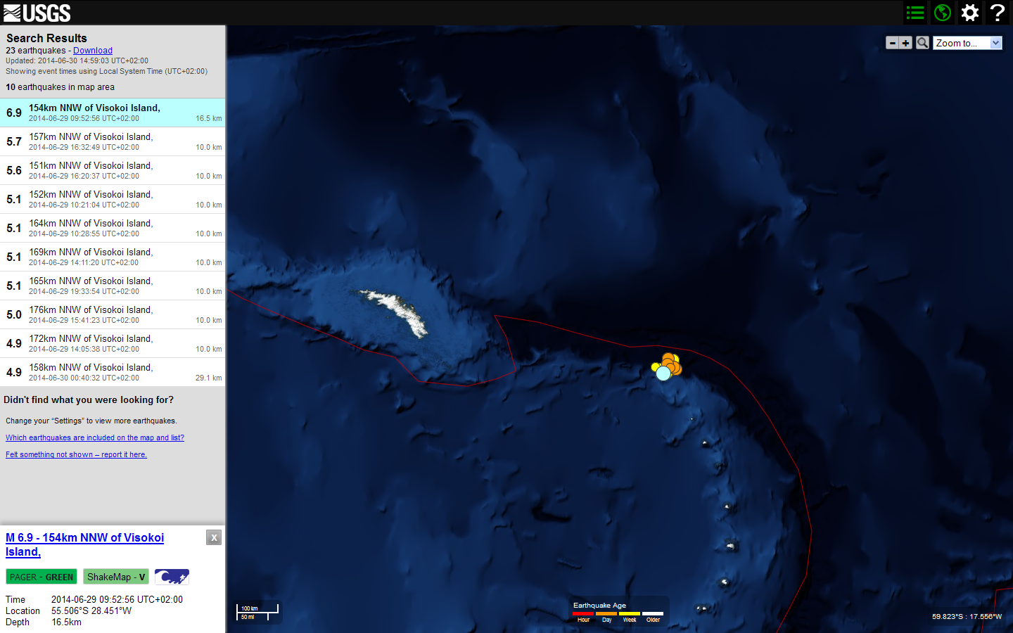
- 6.9 154km NNW of Visokoi Island, 2014-06-29 09:52:56 UTC+02:00 16.5 km
- 6.7 205km SSE of Mata-Utu, Wallis and Futuna 2014-06-29 19:15:08 UTC+02:00 10.0 km
- 6.4 South Indian Ocean 2014-06-14 13:11:00 UTC+02:00 7.1 km
- 6.4 85km WNW of Sola, Vanuatu 2014-06-19 12:17:58 UTC+02:00 59.9 km
- 6.4 197km NW of Hihifo, Tonga 2014-06-29 17:52:22 UTC+02:00 10.0 km
- 6.3 87km SSE of Raoul Island, New Zealand 2014-06-23 21:21:48 UTC+02:00 20.0 km
- 6.3 55km ESE of Buldir Island, Alaska 2014-06-24 05:15:36 UTC+02:00 4.0 km
- 6.2 85km SSE of Raoul Island, New Zealand 2014-06-23 22:06:19 UTC+02:00 20.0 km
- 6.2 134km ESE of Iwo Jima, Japan 2014-06-29 07:56:31 UTC+02:00 43.2 km
- 6.2 Bonin Islands, Japan region 2014-06-30 21:55:32 UTC+02:00 512.4 km
- 6.0 6km WNW of Little Sitkin Island, Alaska 2014-06-23 23:11:41 UTC+02:00 106.8 km
134 Beben Magnitude 5++ (Vormonat: 128)
- 5.9 83km SE of Raoul Island, New Zealand 2014-06-24 00:20:08 UTC+02:00 35.0 km
- 5.9 3km ENE of Little Sitkin Island, Alaska 2014-06-24 00:29:51 UTC+02:00 103.1 km
- 5.8 North of Ascension Island 2014-06-30 03:46:23 UTC+02:00 8.0 km
- 5.7 North Indian Ocean 2014-06-01 12:07:12 UTC+02:00 20.0 km
- 5.7 73km WSW of Haines, Alaska 2014-06-04 13:58:58 UTC+02:00 10.0 km
- 5.7 Easter Island region 2014-06-05 19:22:07 UTC+02:00 7.7 km
- 5.7 91km ESE of Iwaki, Japan 2014-06-15 20:19:15 UTC+02:00 22.8 km
- 5.7 46km NW of Valdez, Ecuador 2014-06-16 08:39:31 UTC+02:00 10.0 km
- 5.7 31km ENE of Noatak, Alaska 2014-06-16 14:01:08 U
- 5.9 11km WNW of Little Sitkin Island, Alaska 2014-06-23 23:30:47 UTC+02:00 109.1 km
- TC+02:00 24.2 km
- 5.7 88km WNW of Iquique, Chile 2014-06-19 11:38:37 UTC+02:00 19.3 km
- 5.7 near the coast of Tarapaca, Chile 2014-06-19 21:54:05 UTC+02:00 10.9 km
- 5.7 7km NW of Little Sitkin Island, Alaska 2014-06-24 02:52:28 UTC+02:00 102.6 km
- 5.7 157km NNW of Visokoi Island, 2014-06-29 16:32:49 UTC+02:00 10.0 km
- 5.6 69km E of Severo-Kuril'sk, Russia 2014-06-07 15:11:37 UTC+02:00 55.6 km
- 5.6 Southern Mid-Atlantic Ridge 2014-06-13 21:30:30 UTC+02:00 10.0 km
- 5.6 14km NW of Hanamaki, Japan 2014-06-14 19:31:41 UTC+02:00 92.0 km
- 5.6 18km ENE of Iwaki, Japan 2014-06-15 22:14:50 UTC+02:00 39.8 km
- 5.6 91km WNW of Iquique, Chile 2014-06-20 22:22:28 UTC+02:00 16.4 km
- 5.6 94km S of Raoul Island, New Zealand 2014-06-24 00:15:53 UTC+02:00 35.0 km
- 5.6 14km NNW of Wawa, Philippines 2014-06-25 13:52:03 UTC+02:00 76.7 km
- 5.6 151km NNW of Visokoi Island, 2014-06-29 16:20:37 UTC+02:00 10.0 km
- 5.6 193km WNW of Hihifo, Tonga 2014-06-29 20:24:30 UTC+02:00 10.0 km
- 5.5 36km NE of Noatak, Alaska 2014-06-07 06:43:32 UTC+02:00 18.6 km
- 5.5 106km E of Artyom, Azerbaijan 2014-06-07 08:05:30 UTC+02:00 35.3 km
- 5.5 107km SSE of San Andres, Colombia 2014-06-16 15:26:46 UTC+02:00 18.5 km
- 5.5 87km WNW of Iquique, Chile 2014-06-20 21:53:32 UTC+02:00 13.5 km
- 5.5 62km SSW of Bilungala, Indonesia 2014-06-21 23:51:51 UTC+02:00 115.0 km
- 5.4 45km SSW of Jarm, Afghanistan 2014-06-14 05:58:42 UTC+02:00 206.6 km
- 5.4 Pacific-Antarctic Ridge 2014-06-16 03:55:47 UTC+02:00 12.1 km
- 5.4 46km ESE of Kainantu, Papua New Guinea 2014-06-23 15:47:43 UTC+02:00 121.3 km
- 5.4 90km SSE of Raoul Island, New Zealand 2014-06-23 22:28:02 UTC+02:00 25.6 km
- 5.4 161km SSE of Raoul Island, New Zealand 2014-06-23 23:08:53 UTC+02:00 10.0 km
- 5.4 35km E of Buldir Island, Alaska 2014-06-24 10:12:35 UTC+02:00 35.0 km
- 5.4 107km SSE of Raoul Island, New Zealand 2014-06-26 00:46:41 UTC+02:00 10.0 km
- 5.4 44km SSE of Bilungala, Indonesia 2014-06-26 13:28:21 UTC+02:00 138.6 km
- 5.3 179km S of L'Esperance Rock, New Zealand 2014-06-02 08:31:39 UTC+02:00 10.0 km
- 5.3 162km WNW of Haines Junction, Canada 2014-06-05 07:44:28 UTC+02:00 1.0 km
- 5.3 Halmahera, Indonesia 2014-06-06 23:42:32 UTC+02:00 69.9 km
- 5.3 106km WSW of Panguna, Papua New Guinea 2014-06-10 20:26:14 UTC+02:00 14.6 km
- 5.3 95km SE of Shimoda, Japan 2014-06-16 19:42:23 UTC+02:00 136.8 km
- 5.3 34km ENE of Bitung, Indonesia 2014-06-17 21:56:21 UTC+02:00 79.9 km
- 5.3 60km S of Amukta Island, Alaska 2014-06-20 14:16:46 UTC+02:00 26.2 km
- 5.3 168km N of Tobelo, Indonesia 2014-06-22 18:34:56 UTC+02:00 48.0 km
- 5.3 110km SSE of Raoul Island, New Zealand 2014-06-23 22:23:32 UTC+02:00 9.2 km
- 5.3 102km SSE of Raoul Island, New Zealand 2014-06-24 02:46:09 UTC+02:00 35.0 km
- 5.3 87km S of Raoul Island, New Zealand 2014-06-30 13:36:05 UTC+02:00 22.7 km
- 5.3 99km SSE of Raoul Island, New Zealand 2014-06-30 22:45:34 UTC+02:00 45.1 km
- 5.2 14km SW of San Bartolo, Peru 2014-06-03 23:34:14 UTC+02:00 47.9 km
- 5.2 12km NNW of Ofunato, Japan 2014-06-08 07:24:32 UTC+02:00 88.7 km
- 5.2 56km W of Panguna, Papua New Guinea 2014-06-09 14:25:18 UTC+02:00 35.0 km
- 5.2 23km NW of Bulata, Philippines 2014-06-09 23:45:12 UTC+02:00 10.0 km
- 5.2 120km WSW of Panguna, Papua New Guinea 2014-06-10 20:48:59 UTC+02:00 41.5 km
- 5.2 70km W of Khuzdar, Pakistan 2014-06-13 08:17:05 UTC+02:00 25.0 km
- 5.2 9km SE of Cuilco, Guatemala 2014-06-16 12:04:32 UTC+02:00 10.0 km
- 5.2 58km S of Hirara, Japan 2014-06-18 04:47:09 UTC+02:00 23.1 km
- 5.2 80km NW of Iquique, Chile 2014-06-19 21:59:42 UTC+02:00 16.7 km
- 5.2 Southern Mid-Atlantic Ridge 2014-06-20 05:04:13 UTC+02:00 15.7 km
- 5.2 46km SW of Taron, Papua New Guinea 2014-06-20 17:46:44 UTC+02:00 52.4 km
- 5.2 Southern Mid-Atlantic Ridge 2014-06-21 11:21:21 UTC+02:00 10.0 km
- 5.2 Java, Indonesia 2014-06-22 08:38:50 UTC+02:00 70.7 km
- 5.2 85km ENE of Hihifo, Tonga 2014-06-23 07:33:30 UTC+02:00 10.0 km
- 5.2 22km S of Little Sitkin Island, Alaska 2014-06-23 23:00:00 UTC+02:00 114.1 km
- 5.2 16km NNW of Little Sitkin Island, Alaska 2014-06-24 08:20:23 UTC+02:00 124.3 km
- 5.2 Kermadec Islands, New Zealand 2014-06-24 10:05:52 UTC+02:00 9.4 km
- 5.2 3km NW of Little Sitkin Island, Alaska 2014-06-25 02:03:05 UTC+02:00 113.1 km
- 5.2 50km NW of Lordsburg, New Mexico 2014-06-29 06:59:33 UTC+02:00 5.0 km
- 5.2 9km NE of Zaqatala, Azerbaijan 2014-06-29 19:26:12 UTC+02:00 34.4 km
- 5.1 38km SSW of Tympakion, Greece 2014-06-01 14:05:51 UTC+02:00 32.2 km
- 5.1 142km WNW of Pangai, Tonga 2014-06-03 03:27:19 UTC+02:00 253.0 km
- 5.1 Pacific-Antarctic Ridge 2014-06-03 06:40:00 UTC+02:00 18.0 km
- 5.1 New Ireland region, Papua New Guinea 2014-06-05 03:16:09 UTC+02:00 341.4 km
- 5.1 33km WSW of Camana, Peru 2014-06-10 06:03:26 UTC+02:00 63.7 km
- 5.1 200km NW of Sorong, Indonesia 2014-06-12 06:33:38 UTC+02:00 38.9 km
- 5.1 36km N of Finschhafen, Papua New Guinea 2014-06-14 00:59:42 UTC+02:00 69.0 km
- 5.1 81km NNW of Curup, Indonesia 2014-06-19 02:51:17 UTC+02:00 169.4 km
- 5.1 177km NW of Neiafu, Tonga 2014-06-21 15:24:20 UTC+02:00 256.9 km
- 5.1 96km E of Sulangan, Philippines 2014-06-22 11:09:00 UTC+02:00 46.7 km
- 5.1 33km ENE of Norsup, Vanuatu 2014-06-23 11:10:14 UTC+02:00 149.5 km
- 5.1 157km WSW of Abepura, Indonesia 2014-06-23 17:13:04 UTC+02:00 53.7 km
- 5.1 168km SE of Raoul Island, New Zealand 2014-06-23 22:59:07 UTC+02:00 10.0 km
- 5.1 11km N of Little Sitkin Island, Alaska 2014-06-24 00:03:28 UTC+02:00 117.3 km
- 5.1 Kermadec Islands, New Zealand 2014-06-24 00:33:47 UTC+02:00 10.0 km
- 5.1 Kermadec Islands, New Zealand 2014-06-24 01:53:26 UTC+02:00 10.0 km
- 5.1 Mid-Indian Ridge 2014-06-24 07:55:11 UTC+02:00 10.0 km
- 5.1 75km SSE of Raoul Island, New Zealand 2014-06-24 13:29:55 UTC+02:00 10.0 km
- 5.1 107km SSE of Raoul Island, New Zealand 2014-06-24 18:53:44 UTC+02:00 26.6 km
- 5.1 170km E of Ndoi Island, Fiji 2014-06-25 06:26:12 UTC+02:00 314.3 km
- 5.1 97km S of Boal Atas, Indonesia 2014-06-26 02:12:22 UTC+02:00 67.4 km
- 5.1 299km ENE of Hasaki, Japan 2014-06-27 13:10:38 UTC+02:00 10.0 km
- 5.1 152km NNW of Visokoi Island, 2014-06-29 10:21:04 UTC+02:00 10.0 km
- 5.1 164km NNW of Visokoi Island, 2014-06-29 10:28:55 UTC+02:00 10.0 km
- 5.1 169km NNW of Visokoi Island, 2014-06-29 14:11:20 UTC+02:00 10.0 km
- 5.1 165km NNW of Visokoi Island, 2014-06-29 19:33:54 UTC+02:00 10.0 km
- 5.1 57km SW of Pagan, Northern Mariana Islands 2014-06-30 13:37:25 UTC+02:00 303.0 km
- 5.0 188km W of Abepura, Indonesia 2014-06-01 17:31:34 UTC+02:00 44.0 km
- 5.0 199km NNE of Bitung, Indonesia 2014-06-01 21:01:51 UTC+02:00 111.2 km
- 5.0 51km ENE of Cortes, Philippines 2014-06-02 03:04:10 UTC+02:00 55.1 km
- 5.0 215km WNW of Lautoka, Fiji 2014-06-03 21:53:06 UTC+02:00 9.9 km
- 5.0 43km WNW of Ambunti, Papua New Guinea 2014-06-04 07:02:36 UTC+02:00 79.3 km
- 5.0 84km SW of Iquique, Chile 2014-06-04 19:04:27 UTC+02:00 13.7 km
- 5.0 near the coast of Tarapaca, Chile 2014-06-05 22:19:29 UTC+02:00 35.1 km
- 5.0 Scotia Sea 2014-06-06 06:38:56 UTC+02:00 10.0 km
- 5.0 14km NNW of Suhe, China 2014-06-10 01:54:15 UTC+02:00 18.5 km
- 5.0 97km SE of Laiwui, Indonesia 2014-06-10 21:26:01 UTC+02:00 41.2 km
- 5.0 134km SE of Karpathos, Greece 2014-06-11 05:53:41 UTC+02:00 74.0 km
- 5.0 102km SSW of Naze, Japan 2014-06-11 09:31:00 UTC+02:00 32.8 km
- 5.0 12km ENE of Placer, Philippines 2014-06-11 11:08:23 UTC+02:00 44.3 km
- 5.0 116km W of Panguna, Papua New Guinea 2014-06-12 23:15:52 UTC+02:00 48.5 km
- 5.0 16km SW of Karpathos, Greece 2014-06-13 02:34:51 UTC+02:00 65.3 km
- 5.0 Izu Islands, Japan region 2014-06-13 07:50:46 UTC+02:00 26.2 km
- 5.0 10km SE of Nueva Concepcion, Guatemala 2014-06-13 14:26:32 UTC+02:00 74.2 km
- 5.0 16km W of Kishtwar, India 2014-06-13 15:32:53 UTC+02:00 46.2 km
- 5.0 90km SSW of Kirakira, Solomon Islands 2014-06-14 13:08:15 UTC+02:00 10.0 km
- 5.0 244km E of Ittoqqortoormiit, Greenland 2014-06-16 16:24:32 UTC+02:00 13.7 km
- 5.0 161km SSE of Sinabang, Indonesia 2014-06-17 18:04:42 UTC+02:00 32.7 km
- 5.0 36km NE of Bandar-e Ganaveh, Iran 2014-06-21 00:54:19 UTC+02:00 10.0 km
- 5.0 Southern Mid-Atlantic Ridge 2014-06-21 13:08:25 UTC+02:00 14.6 km
- 5.0 32km NNE of San Juan Bautista, Peru 2014-06-22 20:05:53 UTC+02:00 68.9 km
- 5.0 86km SSE of Raoul Island, New Zealand 2014-06-24 06:13:08 UTC+02:00 31.4 km
- 5.0 Rat Islands, Aleutian Islands, Alaska 2014-06-24 08:55:31 UTC+02:00 113.4 km
- 5.0 118km SSE of Raoul Island, New Zealand 2014-06-24 22:07:56 UTC+02:00 35.0 km
- 5.0 Prince Edward Islands region 2014-06-25 11:29:56 UTC+02:00 17.5 km
- 5.0 109km SSE of Raoul Island, New Zealand 2014-06-26 04:30:06 UTC+02:00 35.0 km
- 5.0 45km ENE of Amatignak Island, Alaska 2014-06-26 11:03:03 UTC+02:00 50.7 km
- 5.0 Western Indian-Antarctic Ridge 2014-06-27 22:10:15 UTC+02:00 10.0 km
- 5.0 120km E of Bitung, Indonesia 2014-06-29 09:19:24 UTC+02:00 34.4 km
- 5.0 176km NNW of Visokoi Island, 2014-06-29 15:41:23 UTC+02:00 10.0 km
- 5.0 180km NNW of Visokoi Island, 2014-06-30 17:44:25 UTC+02:00 10.0 km


